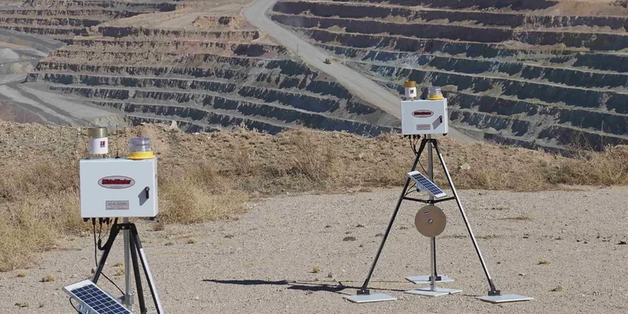
In Fontana, the ground doesn't always give you a warning before it moves. We've seen projects near the Sierra Avenue corridor where the soil profile shifted from stiff alluvium to loose channel deposits within 30 feet of trench depth, completely changing the deformation pattern overnight. That's why we approach every monitoring plan with the assumption that the subsurface model is only a starting point. Our team deploys automated inclinometer strings and total station networks that feed data every 15 minutes, so the site superintendent gets an alert before a deflection hits the trigger threshold. For deeper cuts exceeding 20 feet, we often integrate vibration monitoring when compaction rigs or pile driving equipment operate within the zone of influence. The combination of real-time shape arrays and manual optical survey verification gives us a redundant system that works even when one sensor fails. In a city like Fontana, where the water table can fluctuate seasonally and fill old gravel pits, this layered approach is what keeps excavations stable and crews safe. We also cross-reference the readings with the initial geotechnical baseline report, and if the behavior deviates from the predicted envelope, we coordinate directly with the shoring designer to adjust the slope stability assumptions or reinforce the retaining walls with additional tiebacks.
An inclinometer that's installed flush with the casing and read daily is worth more than a hundred expert opinions when the trench hits a lens of running sand.
How we work
A common mistake we see on Fontana job sites is relying solely on visual inspection of the trench box or soldier pile wall without instrumenting the surrounding ground. The problem is that surface cracks behind the excavation can appear hours after the subsurface deformation has already exceeded allowable limits, especially in the sandy silts that blanket much of the Jurupa fan. Our monitoring programs always start with a baseline survey before the first bucket of soil is removed, capturing the zero reading for inclinometers, piezometers, and settlement plates. We then set threshold values based on the empirical performance criteria from Clough & O'Rourke (1990) and the project-specific allowable angular distortion. For excavations adjacent to existing structures, we add crack meters and tilt sensors on the neighboring footings, linking them to a cloud dashboard that the structural engineer reviews daily. When we detect a trend toward the yellow-alert zone, we don't wait for the weekly meeting; we call the contractor immediately and suggest adjustments to the excavation sequence or dewatering rate. This proactive rhythm has prevented more than a few overnight emergencies in the Inland Empire. We also combine the monitoring data with laboratory index tests when the excavated material doesn't match the boring logs, running quick
atterberg limits analyses to confirm if the clay fraction is high enough to delay drainage and increase lateral pressure on the shoring. For projects where the excavation crosses the groundwater table, we pair the inclinometer data with
in-situ permeability measurements to calibrate the dewatering pump schedule and avoid piping failures at the base of the cut.
Local geotechnical context
OSHA Subpart P (29 CFR 1926.650) is the baseline, but for Fontana's ground conditions we find that compliance alone doesn't guarantee safety. The city sits on the distal part of the Cucamonga alluvial fan, where buried channel deposits create isolated pockets of cohesionless sand and gravel that can ravel at slopes as flat as 1.5H:1V when saturated. The real risk isn't the predictable clay cut; it's the unexpected lens that sloughs without warning, undermining the shoring and potentially trapping a crew in the trench. Our monitoring plan for every Fontana project includes a geologist's walkover during the first two days of excavation to spot these stratigraphic transitions before they become hazards. We also correlate real-time inclinometer drift with the excavation rate: if the wall deflection accelerates while the dig is paused, that's a red flag for pore pressure equalization and possible basal heave. In those cases, we recommend pausing the excavation and verifying the dewatering system's performance before the bottom of the cut becomes unstable. For excavations deeper than 15 feet in Fontana, we also require a liquefaction screening if the groundwater table is within 10 feet of the base, because the city's proximity to the San Andreas and San Jacinto faults makes seismic-induced soil movement a credible operational hazard during the construction window.
Quick answers
How much does geotechnical excavation monitoring cost for a typical Fontana project?
How often are the instruments read during an excavation in Fontana?
We set the automated systems to sample every 15 minutes and push alerts immediately if a threshold is crossed. Manual readings with an inclinometer probe and digital level are taken daily during active excavation and at least twice per week during pauses. If the excavation is within 10 feet of an occupied building, we increase manual verification to twice daily until the permanent bracing is installed and the deflection trend flattens.
What triggers an alert in your monitoring system?
We use a three-tier system calibrated to the project's allowable deformation criteria. The green zone is normal behavior within the predicted range. The yellow alert triggers at 70% of the design allowable deflection or 0.5 in/sec PPV on adjacent structures, and we notify the contractor with a recommendation to adjust the dig sequence. The red alert triggers at 90% of the allowable or if the rate of movement accelerates overnight, and we require an immediate work stoppage until the shoring designer reviews the data and confirms it's safe to proceed.
Do you provide monitoring for trenchless construction methods in Fontana?
Yes. For microtunneling and pipe jacking operations, we install surface settlement arrays and subsurface extensometers above the tunnel crown to track ground loss in real time. We also monitor the jacking thrust and lubricant pressure to correlate with the volume of soil entering the face, which helps prevent inadvertent settlement under Fontana's arterial roads like Foothill Boulevard and Sierra Avenue.